Amazing Store Finder
Ideal Store Locator Plugin (iStoreLocator) works with Google Maps API which allows your website visitors to easily locate stores/contacts on the map. You can load a KML, XML OR CSV file with the locations. It also works with Contact Enhanced Component, so it comes packed with a number of features and easy user interface for both the back and the front-end; with the iStoreLocator plugin you can list stores and business locations under different categories.
A powerful and elegant store locator for your website.
We carefully crafted the store locator panel layout to be optimized for the best viewing experience no matter the browsing device you are using. Compatible with Bootstrap version 2 and 3 and HTML5, the easy to customize layout will give your business website visitors a responsive experience that is elegant and intuitive.
Features:
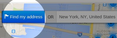
Geolocation Lookup
Built-in Geolocation lookup tool helps users find their current position so they do not have to type their current address to get direction to the nearest store. Click on the 'Find My address' button next to the address to find your current position.
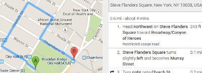
Google Maps Directions
Your website visitors can take advantage of the Google Map Directions by a click on a button. Suggested direction is pointed on the map and step by step directions are displayed on the right.
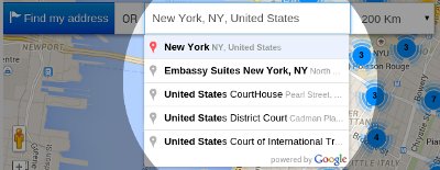
Auto Complete Address Search
The Auto Complete Address Search field provides a type-ahead-search behavior of the Google Maps search field. When a user starts typing an address, autocomplete will fill in the rest. Instead of an address the user can also type places like museums, city halls,...
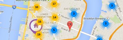
Marker Clusters
Plotting hundreds of markers on a map can quickly lead to a degraded user experience. Too many markers on the map cause both visual overload and sluggish interaction with the map. To overcome this poor performance, the information displayed on the map needs to be simplified. This is done with Marker Cluster. It works by iterating though the markers and adding each one into the closest cluster if it is within in a minimum square pixel bounds
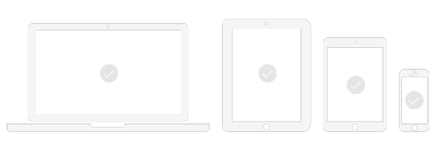
Optimized for mobile devices
Ideal Store Locator is completely optimized and responsive across a wide range of end-user devices to provide an optimal shopping experience for mobile phones, tablets, PC and Mac. It uses the Bootstrap version included in the Joomla source, but it's also compatible with Bootstrap v3 in case your template is loading a more recent version.
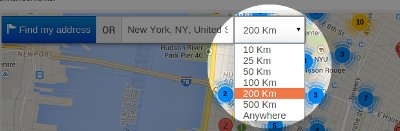
Filter by distance
Your website visitors can easily find stores nearby using the distance filter. In the plugin Options you can change the default distance unit
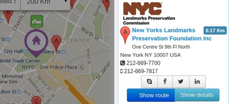
Location/Store info
A list with all locations is displayed on the right of the map. It displays the image, distance to the location and some contact information like address, phone and links to social media. The Show Details button only works when the source is set to Contact Enhanced.
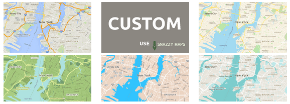
Map Styles
As of version 3 of the Google Maps API custom styles can now be applied to maps. This allows you to pick a style that matches the theme of their website.
You can create your own style using the Google Styled Maps Wizard and copy the JSON code to this field OR use an existing map from snazzymaps.com
Demonstration
The demo below uses the US Museums database with over 35.000 entries in order to demonstrate how fast iStoreLocator works with a very large database. Search for "New York, NY" for testing purpose.
Installation
- Select Extensions → Extension Manager from the drop-down menu of the Joomla! Administrator Panel. Then select the Install menu item in the Extension manager screen that appears.
- Select the zip file and click on the Upload & Install button;
- Select Extensions → Plugin Manager from the drop-down menu and enable the Ideal Store Locator System Plugin.
Usage
In order to display a Store/Contact Locator add the folloing syntax to a content item (article):
Loads all contacts and sets the height for the map:
{istorelocator height=|600|}
Loads all contacts from category 1 and sets the height for the map:
{istorelocator height=|600| category=|1|}
Loads all contacts from category 1, 2 and 3 and sets the height for the map:
{istorelocator height=|600| category=|1,2,3|}
Ability to filter by city, state and/or country and ignore any search. Example Syntax:
{istorelocator category=|78| filter_city=|Boston| filter_state=|MA| filter_country=|USA| zoom=|10| firstload-loadall=|1| firstload-limit=|9999| firstload-maxdistance=|123456| }
{istorelocator height=|600| source=|xml| file=|GreatBritain-Attractions.xml|} set the source to XML and loads the XML file containing locations
{istorelocator height=|600| source=|csv| file=|Germany-CastleFortSchlossRuins.csv|} Set the source type to CSV (Comma Separated Values) and load file with locations
{istorelocator height=|600| source=|kml| file=|example.kml|} Set source type to KML (Google Earth) and loads file with locations
Plugin Options
Select Extensions → Plugin Manager from the drop-down menu and edit the Ideal Store Locator System Plugin. There you'll find all plugin options like:
Under the "Basic" tab:
- Default location: The initial Map center in case the Auto detect Geo Location fails. Just the latitude and longitude will be used, so this address will not be displayed anywhere.
- Default zoom level;
- Scroll wheel zooming;
- MapType Control;
- Map Type: Roadmap (default and recommended), Satellite, Hybrid, Terrain;
- Navigation Control;
- Home Marker Icon: Defines an image to be used as the home icon for a Marker. Image Directory:
/plugins/system/istorelocator/assets/images/markers - Directions Travel Mode; Default Driving
- Link To Google Maps: When enabled displays a Link to maps.google.com (prefilled with the from and to coordinates) in the direction container
Under the "Map Style" tab:
- As of version 3 of the Google Maps API custom styles can now be applied to maps. This allows you to pick a style that matches the theme of their website.
You can create your own style using the Google Styled Maps Wizard and copy the JSON code to this field OR use an existing map from snazzymaps.com
Under the "Search" tab:
- Position: Location to display the Search form (inside the map OR above it);
- Result Limit: Maximum number of results per search;
- Geolocate: Whether to display a Geolocate button, Geolocate on page load OR both;
- Geolocate button class: Customize the button class using Bootstrap button style (styling may change depending on your front-end template). Options for this template are displayed below, but this might change depending on your template:
- Unit System: The unit system to use when displaying distance. Metric will display in Kilometers and Imperial (English) will display in Miles;
- Max Distance List: Number separated by commas to build a list. Set to 0 to hide and add 123456 to display the "Anywhere" as the last option.
- Selected Max Distance: Select one of the values from the Max Distance List to display as the default value;
Under the "Location List" tab:
- Show route: Whether to hide or show directions button. Also set the Bootstrap button style (styling may change depending on your front-end template). Options are the same as the ones shown in the Geolocate Button Class.
- Show distance: Whether or not show the distance label and it's styling (styling may change depending on your front-end template). Options:Primary Info Success Warning Danger Default
- Source: There are a few options to load the locations: The best option is to load them using:
- Contact Enhanced Component (the best option in our opinion),
- XML (see example) (second best option in our opinion),
- CSV file (see example) (third best option in our opinion);
- KML (see example). KML is the file generated from Google Earth. It's easy to create a file using Google Earth, however it doesn't allow you to use all iStoreLocator features.
- File: The source file for the XML, KML or CSV file. Upload your files to /plugins/system/istorelocator/data/
- Show details: Whether or not show the details button and it's styling. If the source is Contact Enhanced, the details button will link to the Contact page. Styling may change depending on your front-end template.
- Image;
- Webpage;
- Skype;
- Facebook;
- Twitter;
- Miscellaneous (more info);
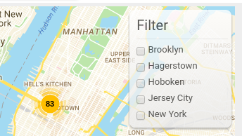
Under the "Filter Groups" tab:
Displays a list of tags (in checkboxes) which allow users to filter the locations by, displaying only locations that match the selected tags. If Marker Clusters option is enabled it will recalculate the markers in each cluster;
The source of the tags can be one of the following:
- Name
- Category Only available when using with Contact Enhanced Component
- Metakey Meta Keywords
- City
- State
- Country
- Postcode
- Tags Only available when using with Contact Enhanced Component
Under the "Language Editor" tab:
If your site is for one language only you can use the options under this tab to change the language strings for this plugin. Otherwise please use the Extensions -> Languages -> Overrides OR translate in Transifex to your language;
Under the "Advanced" tab:
- Force Bootstrap: The script for this plugin is loaded after the page is rendered and in order to avoid incompatibility with other extensions and templates it doesn't load Bootstrap and jQuery by default. If your template or other extensions are not loading these two javascript libraries, than please enable this option and choose which module positions you want to force loading these files;
- Menu Item: Select the Menu Item(s) you want to force loading Bootstrap and jQuery;
- Load FontAwesome: Some icons like the Social media icons are loaded using FontAwesome. You can disable if your template is already loading it;
- Custom CSS: Allows you to add custom CSS rules;
- Custom Javascript: Allows you to add custom Javascript;
Change Log:
Version 3.9.10 (May 08, 2020)
- + Added CSV editor;
Version 3.9.8 (Sept 11, 2019)
- # Fixed Ideal Store Locator search integration with Contact Enhanced Component;
Version 3.9.2 (March 24, 2019)
- # Fixed the search results when using the
filter-searchvariable in the query string with thesearch_fields=metakeyvariable;
Version 3.9.1 (January 18, 2019)
- + Added Fullscreen control options to iStoreLocator;
- - Remove deprecated Joomla! code in order to add compatibility with Joomla! 4.0;
- # Fixed Geolocation feature stating that the daily limit was reached when no query had yet been done;
- + Added option to display prepare More information (Miscellaneous) Field content using Joomla content plugins;
- + Added option to show/hide the instructions and Distance Tool notes on first load;
- # Fixed wrong image and icon path error in the browser's console;
Version 3.7 (Jul/4/2017):
- + Added option to filter by Contact Enhanced Category when the module (included in Contact Enhanced PRO package) is assigned to a CE Category or Categories menu item;
- + Updated Font-awesome library to 4.7.0;
- # Fixed incompatibility with plugins which generated Facebook Open Graph Meta Tags;
- # Fixed Result Limit not working when the source was set to CSV, XML or KML files;
Version 3.6 (Jun/30/2016):
- + Added ability to filter by city, state and/or country and ignore any search. Example Syntax:
{istorelocator category=|78| filter_city=|Boston| filter_state=|MA| filter_country=|USA| zoom=|10| firstload-loadall=|1| firstload-limit=|9999| firstload-maxdistance=|123456| }; - + Ability to GeoCode Contact Enhanced Contacts;
- + Because of a Google Chrome restriction, iStoreLocator won't load the 'Find my Location' button for users using Chrome version 50+ when the site doesn't have a valid SSL certificate (https://);
- + Added ability to add template HTML override. For more information on Template HTML overrides visit the Joomla Documentation.
- # Fixed issue not showing the default Clusterer's image;
- # Fixed issue in iPhone (Safari) zooming in when clicking on the Range (distance) select list (Dropdown);
- + Add ability to filter by city, state and/or country and ignore any search. Example Syntax:
{istorelocator category=|78| filter_city=|Boston| filter_state=|MA| filter_country=|USA| zoom=|10| firstload-loadall=|1| firstload-limit=|9999| firstload-maxdistance=|123456| }; - + Ability to GeoCode Contact Enhanced Contacts;
- # Fixed issue not showing the default Clusterer's image;
- + Ability to auto search using by adding a few search parameters to the query string for example:
https://yoursite.com/path/to/iStoreLocator.html?country=Brazil&city=Curitiba&state=PR
Load all* on First load must be set to No and Geolocate must be set to Show or No - + Ability to edit the Cluster style;
- + Ability to change plugin options in the plugin syntax, overriding content plugin options;
- + Added option to disable auto complete when typing addresses, this way you can ask your users to simply add a zip (postal) code;
- + Improved navigation on mobile devices;
- + Added option to disable Marker Cluster and/or change it's settings;
- + Added option to display a radius circle overlay;
- + Added option to allow users to filter locations by tags (category, metakey, Name, city, state, country or postal code);
- + Added category and metakey fields to the CSV and XML source files in order to be compatible with the filter location;
- + Map is now updated when the search radius select list is changed;
- + Added option to load website link in a new window or on the same window;
- + Added more map controls, now you can choose whether or not to display the StreetView, Pan and Zoom controls and you can also choose their position in the map;
- # Fixed issue when loading all locations at once when source file is XML, KML or CSV;
 Recommend to a friend